On Monday, the weather was too nice to not be out driving so I decided to take a spin up to Mt. Rainier to see if the roundtrip could be done on a single charge. Thanks to Todd Laney for planting the seed by suggesting it as a possible Roadster owner drive route to follow our adventure on Sunday.
I used Google maps to plot a route and get mileage/time estimates. Google estimated the drive at about 2:30 and my goal was to make the roundtrip in four hours. On the way back I took Highway 18 instead of Cedar Grove Rd SE, which wasn't that scenic and smelled of landfill.
I left our house at 4:00 pm, with a full standard mode charge at 194 ideal miles. I reset the trip meter so I could easily track mileage and energy used. I left later than I had hoped, and I paid for it by being stuck in traffic pretty much the entire way from Issaquah to Enumclaw. That didn't help with my four-hour goal.
Give or take a few stunning views of Rainier near Black Diamond, the drive didn't get fun until I left Enumclaw (and the traffic) and got onto SR 410, a two-lane road through forest. I was pushing to make up lost time, but mindful of the risk of deer crossing the road, so I kept the speedometer at or a little above the speed limit. I didn't see much traffic and only passed one vehicle, a van going well below the speed limit.
I neglected to record state when I entered the park to begin the ascent up the mountain, but I recall the battery being around 90 ideal miles and the trip odometer would have been around 70. At about 4 miles from Sunrise, the trip and battery state crossed at 79 miles driven and 79 ideal miles left in the battery pack. If I were on level ground, I would have been considering bailing at that point, but I knew I had used extra energy climbing that I would get back on the descent. Also, I was still driving in standard mode, so I could switch into range mode to get another 25 miles of range.
The best part of the drive was the winding ascent up the mountain, wonderful conditions for the Roadster, although the road was pretty uneven in spots. I was having fun but not being crazy about it. Two thirds of the way up the mountain, I came up behind another car and resigned myself to taking the rest of the drive at his pace, which would have been fine. However, as soon as I came up behind him, he immediately pulled over to let me pass. I don't know whether he was scared of the red sports car, or just really nice. I waved in appreciation as I passed.
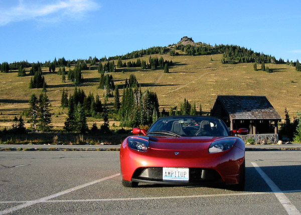
I arrived at Sunrise at 6:08 pm, just a few minutes later than my goal time. I let the car sit for a few minutes while I tracked down a restroom and snapped a quick photo. Ready for the return drive, the trip meter said I had driven 83.7 miles and used 28.01 kWh. The touchscreen altimeter said 6300 ft, temperature at 60 F, with the SOC at 47% and 69 ideal miles (standard mode).
For the descent, I got regen nearly the entire way. I stopped twice on the way down, once at the viewpoint just below Sunrise where I got my cell phone signal back and called to update Cathy on my progress, and at the bottom to record data. At the park exit, 14.0 miles from Sunrise, the battery state was up to 71 ideal miles, a net gain of two ideal miles from the reading at the top.
I was treated to a beautiful sunset with a thin crescent moon just above the horizon as I was finishing up the drive on SR 410 approaching Enumclaw.
I had a TomTom GPS navigation device programmed for the route home, mostly to show me remaining miles and ETA. When I left the summit at 6:20 or so, it was predicting I would get home just before 9:00, which was obviously wrong since I made the trip there in just over two hours. After exiting the park, the ideal miles tracked the remaining miles pretty closely, showing a buffer of about 10 miles the entire way, while the ETA dropped steadily.
I got home at 8:20, missing my four-hour goal by about the length of my stops. The trip meter read 168.8 miles and 41.76 kWh. Our house is about 100 ft elevation, so the trip involved climbing then descending 6,200 feet. The battery pack was showing a temperature reading of four (the highest of the blue ticks), PEM and motor at 3. After sitting for 20 minutes to stabilize, the state of charge read about 5% of the battery left, 9 ideal miles.
Charging back up to full (standard mode) from 240V/40A took 5:20 and put 44 kWh back into the battery pack. The meter on the wall indicated it pulled 50.0 kWh hours, or 296 Wh/mi from wall to wheel, about 12% below my average of 336 Wh/mi.
If Watt-hours per mile doesn't mean anything to you, at 9 cents per kWh for "green power" from Puget Sound Energy, it cost me about $4.50 to drive 168.8 miles, or about 37.5 miles per dollar of green electricity.
My take-away from the drive:
- The roundtrip can be done on a single standard mode charge, but if you have a passenger or are farther away than Sammamish, I'd recommend a range mode charge.
- If you do it on a weekday, start early enough to avoid the evening rush hour.
- Take a credit card: it costs $15 to get into the park via the automated kiosk. Cash might also work.
- Driving through the woods at sunset on a warm day leaves the front of your car covered with a thick layer of bugs.
Updated July 12, 2011: Fixed link to route map.